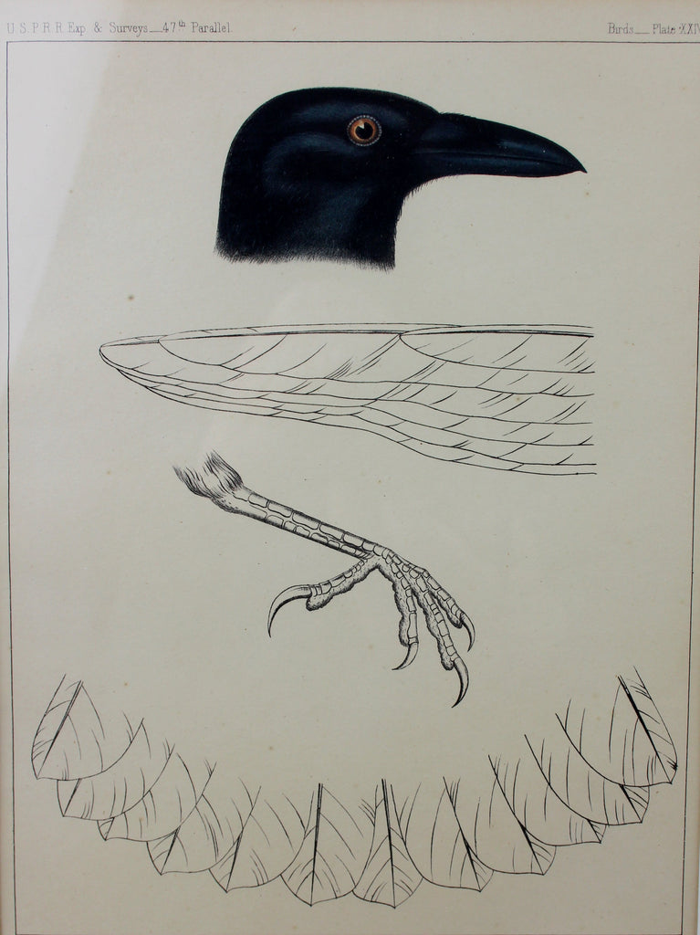
USPRR Plate XXIII Lithograph of Crow/Blackbird of wings and foot, 47th Parallel Ca 1859, #1399 SOLD
$ 200.00
U.S.P.R.R Plate XXIII Color Lithograph of unidentified Crow/Blackbird with detail of wings and foot, 47th Parallel Ca 1859, #1399
Description: #1399 U.S.P.R.R Plate XXIII Color Lithograph of unidentified Crow/Blackbird with detail of wings and foot, 47th Parallel Ca 1859. Framed and matted. Original 150-plus-year-old color lithograph. The plate is from Reports of Explorations and Surveys, To Ascertain the Most Practicable and Economical Route for a Railroad from the Mississippi River To The Pacific Ocean [known more commonly as the U.S.P.R.R.] published by the U.S. Government circa 1859
Dimensions: Frame size: 12" x 15" Sheet size: approximately 8 1/2 x 11 3/8 inches
Condition: Excellent for age
Provenance: From the Brining"s personnel collection. Acquired in the 1970's in British Columbia.
ABOUT THE LITHOGRAPHS by Robert Taft [Excerpt source: Artists and Illustrators of the Old West 1850–1900 (Scribner's, 1953)] Preliminary reports were published from time to time but the complete reports with revisions and additions of the work of subsequent surveys were published in a magnificent and comprehensive twelve volume work with the imposing title, Reports of the Explorations and Surveys to Ascertain the Most Practicable and Economic Route for a Railroad from the Mississippi River to the Pacific Ocean. These volumes, published by the Federal Government between 1855 and 1861, constitute probably the most important single contemporary source of knowledge on Western geography and history and their value is greatly enhanced by the inclusion of many beautiful plates in color of scenery, native inhabitants, fauna and flora of the Western country. Ironically enough, the publication of this monumental work cost the government over $1,000,000; the surveys themselves $455,000. These reports, with earlier versions, are invaluable firsthand sources for the historian of today, and created tremendous interest at the time they were published. They were discussed in the newspapers, talked about in Congress, in homes, on the street, and were reviewed at length in the contemporary magazines. The illustrations in the Report which we shall consider are the so-called "views"; these are of greatest general interest. But it must be kept in mind, as indicated by Senator Harlan, that many scientific (geological, zoological, botanical) illustrations were also included. Many of the illustrations for the geological reports are woodcuts reproduced in the text and a few of these are of sufficient general interest to mention specifically, as has been done later. The "views" are for the most part full page lithographs and are printed in two or three colors on heavy paper, much heavier than the paper used for the text. Many are printed in brown and black, some in green and black and in still others, a third color—blue—has been added. The lithography was done by A. Hoen Co. (Baltimore), J. Bien (New York), Sarony and Co., or Sarony, Major and Knapp (New York), and T. Sinclair (Philadelphia). Evidently, because of the large number of plates required, the same illustration was occasionally lithographed by different firms. As a result, slight differences in views occur, as the lithography was all hand work. Impressions from the same stone vary also, depending upon the number of impressions and on the amount of ink present at each impression. The illustrators for the volumes, all of whom were members of the various survey parties, were eleven in number and included: John C. Tidball, Albert H. Campbell, Richard H. Kern, James G. Cooper, John M. Stanley, John Young, Gustav Sohon, F. W. von Egloffstein, H. B. Möllhausen, W. P. Blake, and Charles Koppel. The artist of the northern survey route, John M. Stanley, deserves more than mere mention for at least two reasons: he is represented by more plates than any other artist employed in any of the surveys, and no early Western artist had more intimate knowledge by personal experience of the American West than did Stanley. (Source Darvills Rare Prints)
Related Products
Sold out


